Description
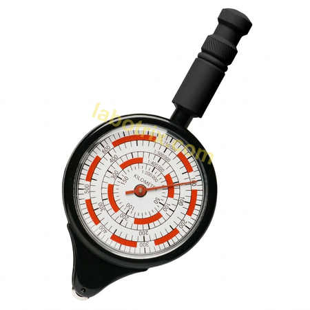
This curvimeter is an instrument for the precise measurement of distances and the length of routes on geographical maps and plans of different scales. It is widely used in geography, geodesy and topography lessons during work with cartographic materials. The measuring wheel of the instrument is rolled along the line of the route, and the result is read from the scale that corresponds to the scale of the map.
The instrument is equipped with a measuring wheel and a sensitive transmission mechanism that transfers the movement of the wheel to the pointer of the dial. Several scales are placed on the dial, which makes it possible to measure distances on maps of different scales without calculations. The centimetre scale allows direct measurement of length in centimetres, where one full turn of the pointer corresponds to 1 centimetre.
The dial carries a scale for maps of 1:5 000, a scale for maps of 1:20 000 and a scale for maps of 1:50 000, together with the centimetre scale in which one full revolution of the pointer equals 1 cm. The measurement accuracy, depending on the scale, is 5 mm on the map. The body is made of impact-resistant plastic and the wheel of an elastic polymer. The instrument needs no power source and is supplied ready for measurement, requiring no additional adjustment. The conditions of use are the premises of an educational institution at an air temperature of +5 to +40 degrees Celsius and relative humidity of 40 to 60 % without condensate. Marking and operating documentation are in Ukrainian, and the marking carries the trade mark, the model and a place for an inventory number. The service life is 5 years and the warranty period is 12 months.
The set includes the curvimeter assembled with its dial and measuring wheel – 1 pc, a passport with a warranty card – 1 pc, and individual transport packaging – 1 pc. The product needs no assembly before first use, as everything required for work is already fitted under factory conditions.
Before measuring, the scale of the map is determined from the inscription in its margins, the pointer is set to zero by turning the wheel, and the wheel is placed at the starting point of the route with gentle pressure that does not damage the map. The wheel is then rolled along the line of the route from the beginning to the end with an even, smooth movement, without lifting it from the map and moving more slowly along the bends; at sharp turns the instrument is stopped, repositioned and the measurement continued. After the measurement the reading is taken from the scale that corresponds to the scale of the map, and the centimetre scale is used for measuring on fragments of a map or on drawings without reference to the scale. Students carry out work with the instrument on maps under the guidance of a geography teacher.
The wheel is lifted vertically from the map at the end of the work and wiped with a dry soft cloth to remove paper residue and dirt, and the body and the dial are also wiped with a soft dry cloth; paper residue is removed from the wheel with a soft brush. The instrument is not wetted or immersed in water, and solvents, alcohol and aggressive cleaning agents are not used. The wheel is not forced to turn in the reverse direction, as that can damage the transmission mechanism, and the transmission mechanism, the pointer and the wheel are not disassembled. The product is stored in a dry room at +5 to +40 degrees Celsius and relative humidity of 80 % without condensation, protected from dust, direct sunlight and vibration, in its original or a similar rigid packaging.